We are getting a ton of smoke down here from all the fires up north. Very unhealthy. Horrible visibility. And it really stinks. Probably the worsed since it got here last week. First day was really bad but today is worse. I guess it is better than the fires themselves.
There are hundreds of fires in Oregon, most of the state is covered in smoke, as is N. California thru Montana... between those waves of thunderstorms earlier in the summer, and many acts of human stupidity, the place is an ash cloud right now. The remains of tropical storm Lidia are working their way up the coast (and mostly offshore), fingers crossed it produces some wetting rains (as opposed to more thunderstorms and new fires from lightening strikes). The next few days should be interesting, as all that moisture eventually comes on shore. Then back to being hot again, especially if hurricane Irma follows it's projected path. That hurricane arriving in the SE will help turn the NW weather hot again (after some brief cooling from Lidia the next few days). Florida, and possibly a large chunk of the eastern seaboard should be taking Irma very very seriously... Good year to bankrupt some insurance companies!
My old nickname was Dr. Dewpoint, cause every time there was a chance of thunderstorms or snow, both very rare here in western Oregon, i'd go off on the dewpoint temperatures (relating to our chances)..... (BS, beyond stupidity, in Atmospheric science OSU 87, just to be uppity, lol)
here's a great link for those who like viewing satellite pics
Hey Judit! Portland is pretty awful right now... cant see any of the surrounding hills... just returned from errands on east side, it's eerie.
Ash is accumulating on cars and wind has picked up, coming down the gorge from the east.
I-84 is now closed due to roadside flare-ups between Hood River and Troutdale.
We leave early Thursday for Sound Summit.... watching routes closely..we have 3 to choose from... staying south of Shasta in McCloud on Thursday, then to Occidental.
Travel safe, all!
My beloved Oregon is burning. This plus the nuke threat is making for a tense week! We have friends who live up the gorge, too.
Yes, LLOLLO, our beloved Oregon is aflame. (And Washington, California, Montana, and fill in the blanks.) There are so many people/animals/dwellings at risk, and land, water, air already in the worst of danger.
Our air got quite a bit better this afternoon/evening but the quality is slipping now and we're back in the Unhealthy zone. The ashes falling reminds me of Mt. St. Helens; there was fine ash down here but I spent some time in King's Valley around that time and there was a half-inch or so of ash. Argh. Be safe, wear N95 masks, arghhhh.
By Thursday traveling may be easier. Man, I hope so. I wonder if you can come down I-5, take Hwy 58 up to 97 and then stay on that to Weed and I-5. I love that route and don't know if there are many fires that way. Less than I-5 south of Eugene, for sure. Please let us know how the trip is. And of course, Sound Summit.
Oregon Evacuations east of Portland as of 10:45pm;
Level 3 evacuation orders, meaning residents should leave immediately, have been ordered for the following communities:
Warrendale
Dodson
Larch Mountain
East Corbett (East of Larch Mtn. Rd.)
Level 2 evacuation orders, meaning residents should be ready to leave at a moment's notice, have been issued for the following communities:
Bridal Veil
Latourell
Part of Cascade Locks
Level 1 evacuation orders, meaning residents should get their belongings prepared to go, have been issued for the following communities:
Areas of Corbett west of Larch Mtn. Rd.
Red Cross shelters are set up at the Yoshida Event Center at Mount Hood Community College in Gresham and at the Skamania County Fairgrounds in Stevenson, Washington for evacuees.
Mt Hood Community College is taking pets too... they're warning everyone west of the fires to start moving livestock now, as the fire has spread 4 miles in the last 3 hours (per satellite), and heading towards the Multnomah Falls area. Meanwhile, the east winds are driving all that smoke into the Portland area and Willamette Valley, while the upper winds are carrying smoke from the CA / Southern Oregon fires north into Oregon at the upper levels. Tomorrow could be one of the worst smoke days in Oregons history, certainly the worst day we've seen yet!
Here's a link for Corvallis air quality, but you can find your town via the link;
It becomes a conundrum. In the mornings and at night, when we would normally have the windows open to dissipate some of the HEAT, we have to keep them closed to keep out the SMOKE!
>>>>we have to keep them closed to keep out the SMOKE!
We were dealing with the same situation last night. Although this town has seen smoke from forest fires before, this is the only time I can remember where it was actually personally caustic and uncomfortable. And the ash on all of the cars and plants this morning is something I haven't seen before either.
Just hope the winds die down and the cooler, wet weather predicted for the end of the week shows up soon.
Our air quality (or lack thereof) is back up to 434, hazardous. Staying inside and I do have a respirator mask rated N95 so I'm okay if I have to go outside.
holy shit, 1 set of friends at Latourell had to evacuate last night...just got word that our friends in Corbett are evacuating now... fire is still moving west towards Troutdale.
Level 1 evac now applies to anyone east of 257th in Troutdale and north of Stark! (Troutdale is west of Corbett towards Portland)
Winds had died down early this morning, so I though they were in the clear. This is devastating, they, like many others who have farm animals, are having to move 5 cats, 2 dogs, a herd of chickens and several goats... plus they may lose their historic log cabin home that used to be Corbett's general store.
Disco Stu -- it's the embers off our huge fir and cedar trees that are getting carried across the river by last night's high winds. Fortunately the small fire that was started last night got extinguished.
Back on the Oregon side, it's still pretty sad.
If anyone knows Breitenbush Hot Springs -- south of Mt. Hood -- and a very special Oregon old-school place... that has been evacuated too, since last week.
>>>>Kids with fireworks started Eagle Creek fire near Portland.
One witness said the kids were filming themselves throwing the fireworks down into a ravine. What's dumber than setting a forest on fire? Filiming yourself doing it.
I grew up spending a lot of time around Breitenbush. My family still own land in Detroit. Wish I could send some of this cold Alaskan rain to all suffering through this.
Fortunately the East winds calmed down, and the winds will turn onshore, so that'll greatly slow the spreading of the fire in the Columbia Gorge (Eagle Creek Fire). Plus, we have rain showers coming up from the SE today, actually got some rain on the Chetco fire last night / this morning, and a thunderstorm went over the Mill fire near Mt Jefferson (breitenbush) last night... so fingers crossed for wetting rains as the remains of Hurricane Lidia slowly works it's way thru the great Pacific NW the next 2 days... of course, there'll be storms too, that'll likely start even more fires! Ay Carumba! Still smokey as hell, hopefully the rain and wind shifts will clear the air a bit!
Still smokey here, air quality 157, merely unhealthy. Hoping it rains soon.
LLOLLO, Ras Tim, this was posted in Facebook by a friend with very strong ties to Breitenbush (she grew up there):
Our day began with a fire drill at 8AM, followed by the first official Spirit Crew Ops meeting. Not the last. Our crew is turning Breitenbush into a rainforest. Really. Sprinklers *everywhere* and they're just getting started. The bridge is covered end-to-end. All of the most important buildings are being soaked. It's getting difficult to walk anywhere in the community without getting wet. These folks are kicking ass and taking names. Thank you!
There is a very moving video of hoses and sprinklers throughout the Breitenbush site, 7 minutes of the videographer walking the paths. LLOLLO, I'll share it to you on Facebook if it lets me.
Top of Page Bottom of Page PermalinkFull Name: treat island
Slightly worse than yesterday
Eugene is slightly worse than yesterday.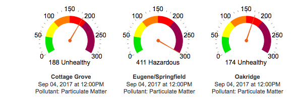
Top of Page Bottom of Page PermalinkFull Name: _________
CRAZY Crazy Microbursts In
CRAZY Crazy Microbursts In Santa Barbara Yesterday !!
Top of Page Bottom of Page PermalinkFull Name: Highnote
Wow Judit, that's bad. There
Wow Judit, that's bad. There is visible smoke here and skies are grey.
Top of Page Bottom of Page PermalinkFull Name: Highnote
...
...
Top of Page Bottom of Page PermalinkFull Name: MarkD
We are getting a ton of smoke
We are getting a ton of smoke down here from all the fires up north. Very unhealthy. Horrible visibility. And it really stinks. Probably the worsed since it got here last week. First day was really bad but today is worse. I guess it is better than the fires themselves.
Hope everyone stays safe and somewhat healthy.
Glad I have my AC. It's bearable inside.
Gary and Rob heading home thru it. Safe travels.
Top of Page Bottom of Page PermalinkFull Name: Druba
There are hundreds of fires
There are hundreds of fires in Oregon, most of the state is covered in smoke, as is N. California thru Montana... between those waves of thunderstorms earlier in the summer, and many acts of human stupidity, the place is an ash cloud right now. The remains of tropical storm Lidia are working their way up the coast (and mostly offshore), fingers crossed it produces some wetting rains (as opposed to more thunderstorms and new fires from lightening strikes). The next few days should be interesting, as all that moisture eventually comes on shore. Then back to being hot again, especially if hurricane Irma follows it's projected path. That hurricane arriving in the SE will help turn the NW weather hot again (after some brief cooling from Lidia the next few days). Florida, and possibly a large chunk of the eastern seaboard should be taking Irma very very seriously... Good year to bankrupt some insurance companies!
Top of Page Bottom of Page PermalinkFull Name: treat island
We're down to a "very
We're down to a "very unhealthy" 280!!!
Top of Page Bottom of Page PermalinkFull Name: treat island
Thanks for the information
Thanks for the information about the storms and water, Noodler.
Top of Page Bottom of Page PermalinkFull Name: Druba
my old nickname was Dr.
My old nickname was Dr. Dewpoint, cause every time there was a chance of thunderstorms or snow, both very rare here in western Oregon, i'd go off on the dewpoint temperatures (relating to our chances)..... (BS, beyond stupidity, in Atmospheric science OSU 87, just to be uppity, lol)
here's a great link for those who like viewing satellite pics
http://www.ssec.wisc.edu/data/geo/#/animation?satellite=goes-west
Top of Page Bottom of Page PermalinkFull Name: treat island
Is your nickname now Dr. Uba?
Is your nickname now Dr.Uba?
Top of Page Bottom of Page PermalinkFull Name: Philzone Refugee
SUMMER FROM HELL!!!
SUMMER FROM HELL!!!
So hot, you might as well jump in the fire....oh, wait.
Top of Page Bottom of Page PermalinkFull Name: Druba
should be Judit, I think
should be Judit, I think Druba came from my days in a reggae band 25 years ago, lol
Top of Page Bottom of Page PermalinkFull Name: MeditateontheQ
Hey Judit! Portland is
Hey Judit! Portland is pretty awful right now... cant see any of the surrounding hills... just returned from errands on east side, it's eerie.
Ash is accumulating on cars and wind has picked up, coming down the gorge from the east.
I-84 is now closed due to roadside flare-ups between Hood River and Troutdale.
We leave early Thursday for Sound Summit.... watching routes closely..we have 3 to choose from... staying south of Shasta in McCloud on Thursday, then to Occidental.
Travel safe, all!
My beloved Oregon is burning. This plus the nuke threat is making for a tense week! We have friends who live up the gorge, too.
Top of Page Bottom of Page PermalinkFull Name: Skitime
It is pretty wild to see the
It is pretty wild to see the ash come down like light snow flurries.
Top of Page Bottom of Page PermalinkFull Name: Skitime
View of Cascade Locks , OR
Top of Page Bottom of Page PermalinkFull Name: treat island
Yes, LLOLLO, our beloved
Yes, LLOLLO, our beloved Oregon is aflame. (And Washington, California, Montana, and fill in the blanks.) There are so many people/animals/dwellings at risk, and land, water, air already in the worst of danger.
Our air got quite a bit better this afternoon/evening but the quality is slipping now and we're back in the Unhealthy zone. The ashes falling reminds me of Mt. St. Helens; there was fine ash down here but I spent some time in King's Valley around that time and there was a half-inch or so of ash. Argh. Be safe, wear N95 masks, arghhhh.
By Thursday traveling may be easier. Man, I hope so. I wonder if you can come down I-5, take Hwy 58 up to 97 and then stay on that to Weed and I-5. I love that route and don't know if there are many fires that way. Less than I-5 south of Eugene, for sure. Please let us know how the trip is. And of course, Sound Summit.
Wishing you good roads. Love.
Top of Page Bottom of Page PermalinkFull Name: Druba
Oregon Evacuations east of
Oregon Evacuations east of Portland as of 10:45pm;
Level 3 evacuation orders, meaning residents should leave immediately, have been ordered for the following communities:
Warrendale
Dodson
Larch Mountain
East Corbett (East of Larch Mtn. Rd.)
Level 2 evacuation orders, meaning residents should be ready to leave at a moment's notice, have been issued for the following communities:
Bridal Veil
Latourell
Part of Cascade Locks
Level 1 evacuation orders, meaning residents should get their belongings prepared to go, have been issued for the following communities:
Areas of Corbett west of Larch Mtn. Rd.
Red Cross shelters are set up at the Yoshida Event Center at Mount Hood Community College in Gresham and at the Skamania County Fairgrounds in Stevenson, Washington for evacuees.
Top of Page Bottom of Page PermalinkFull Name: MarkD
Gotta steal the Smokie.
Gotta steal the Smokie.
Top of Page Bottom of Page PermalinkFull Name: treat island
What's that mean, Mark? And
What's that mean, Mark? And hi!
Top of Page Bottom of Page PermalinkFull Name: treat island
It must be terrifying to be
It must be terrifying to be east of Portland along the Gorge corridor. Hoping for safe passage for all.
Top of Page Bottom of Page PermalinkFull Name: Druba
Mt Hood Community College is
Mt Hood Community College is taking pets too... they're warning everyone west of the fires to start moving livestock now, as the fire has spread 4 miles in the last 3 hours (per satellite), and heading towards the Multnomah Falls area. Meanwhile, the east winds are driving all that smoke into the Portland area and Willamette Valley, while the upper winds are carrying smoke from the CA / Southern Oregon fires north into Oregon at the upper levels. Tomorrow could be one of the worst smoke days in Oregons history, certainly the worst day we've seen yet!
Here's a link for Corvallis air quality, but you can find your town via the link;
http://aqicn.org/city/usa/oregon/corvallis/
Top of Page Bottom of Page PermalinkFull Name: Lord Kalvert
I'm moving to Salem in a
I'm moving to Salem in a month
Please put those fires out by then
thanks
Top of Page Bottom of Page PermalinkFull Name: Def. High
It becomes a conundrum. In
It becomes a conundrum. In the mornings and at night, when we would normally have the windows open to dissipate some of the HEAT, we have to keep them closed to keep out the SMOKE!
Top of Page Bottom of Page PermalinkFull Name: Subway Token
feel for you guys! smoke is
feel for you guys! smoke is not fun.
hope all stay safe.
the earth seems pretty angry these days...
Top of Page Bottom of Page PermalinkFull Name: Ken D.
>>>>we have to keep them
>>>>we have to keep them closed to keep out the SMOKE!
We were dealing with the same situation last night. Although this town has seen smoke from forest fires before, this is the only time I can remember where it was actually personally caustic and uncomfortable. And the ash on all of the cars and plants this morning is something I haven't seen before either.
Just hope the winds die down and the cooler, wet weather predicted for the end of the week shows up soon.
Top of Page Bottom of Page PermalinkFull Name: MarkD
Judit, the Smokie Fire Danger
Judit, the Smokie Fire Danger pic.
Top of Page Bottom of Page PermalinkFull Name: treat island
Oh, I got it, Mark.
Oh, I got it, Mark.
Our air quality (or lack thereof) is back up to 434, hazardous. Staying inside and I do have a respirator mask rated N95 so I'm okay if I have to go outside.
Top of Page Bottom of Page PermalinkFull Name: MarkD
It has cooled off for a few
It has cooled off for a few days here, Judit. Makes avoiding the smoke a little easier. Hoping it gets better for you soon.
Top of Page Bottom of Page PermalinkFull Name: Sycamore Slough
Supposedly one of the fires
Supposedly one of the fires jumped the Columbia around Cascade Locks, crossing over to Washington. I find that difficult to imagine.
Top of Page Bottom of Page PermalinkFull Name: treat island
So much of the western U.S.
So much of the western U.S. is on fire. It's overwhelming.
Top of Page Bottom of Page PermalinkFull Name: Ken D.
>>>>one of the fires jumped
>>>>one of the fires jumped the Columbia around Cascade Locks
Yep. That happened:
http://katu.com/news/local/eagle-creek-fire-grows-to-10000-acres
http://katu.com/news/local/wildfire-now-burning-on-washington-side-acros...
Serious cluster fuck going on. At least so far, they have been able to keep the historic Multnomah Falls Lodge from burning up.
Top of Page Bottom of Page PermalinkFull Name: jeff
There is ash falling from the
There is ash falling from the sky in downtown Seattle today.
Top of Page Bottom of Page PermalinkFull Name: Ken D.
...
...
Top of Page Bottom of Page PermalinkFull Name: _________
Awesome ! Ken !!
Awesome ! Ken !!
Top of Page Bottom of Page PermalinkFull Name: MeditateontheQ
holy shit, 1 set of friends
holy shit, 1 set of friends at Latourell had to evacuate last night...just got word that our friends in Corbett are evacuating now... fire is still moving west towards Troutdale.
Level 1 evac now applies to anyone east of 257th in Troutdale and north of Stark! (Troutdale is west of Corbett towards Portland)
Winds had died down early this morning, so I though they were in the clear. This is devastating, they, like many others who have farm animals, are having to move 5 cats, 2 dogs, a herd of chickens and several goats... plus they may lose their historic log cabin home that used to be Corbett's general store.
Top of Page Bottom of Page PermalinkFull Name: Fly
That photo above is chilling.
That photo above is chilling. All the wind cant help. Breathe safely y'all!
love that smokie bear
Top of Page Bottom of Page PermalinkFull Name: MeditateontheQ
Disco Stu -- it's the embers
Disco Stu -- it's the embers off our huge fir and cedar trees that are getting carried across the river by last night's high winds. Fortunately the small fire that was started last night got extinguished.
Back on the Oregon side, it's still pretty sad.
If anyone knows Breitenbush Hot Springs -- south of Mt. Hood -- and a very special Oregon old-school place... that has been evacuated too, since last week.
Top of Page Bottom of Page PermalinkFull Name: I rang a silent bell
Kids with fireworks started
Kids with fireworks started Eagle Creek fire near Portland.
http://www.cnn.com/2017/09/06/us/oregon-fire-teenager/index.html
Top of Page Bottom of Page PermalinkFull Name: Ken D.
>>>>Kids with fireworks
>>>>Kids with fireworks started Eagle Creek fire near Portland.
One witness said the kids were filming themselves throwing the fireworks down into a ravine. What's dumber than setting a forest on fire? Filiming yourself doing it.
Top of Page Bottom of Page PermalinkFull Name: AK Dread
I grew up spending a lot of
I grew up spending a lot of time around Breitenbush. My family still own land in Detroit. Wish I could send some of this cold Alaskan rain to all suffering through this.
Top of Page Bottom of Page PermalinkFull Name: Druba
Fortunately the East winds
Fortunately the East winds calmed down, and the winds will turn onshore, so that'll greatly slow the spreading of the fire in the Columbia Gorge (Eagle Creek Fire). Plus, we have rain showers coming up from the SE today, actually got some rain on the Chetco fire last night / this morning, and a thunderstorm went over the Mill fire near Mt Jefferson (breitenbush) last night... so fingers crossed for wetting rains as the remains of Hurricane Lidia slowly works it's way thru the great Pacific NW the next 2 days... of course, there'll be storms too, that'll likely start even more fires! Ay Carumba! Still smokey as hell, hopefully the rain and wind shifts will clear the air a bit!
Top of Page Bottom of Page PermalinkFull Name: Def. High
Air slightly better today
Air slightly better today since the wind turned onshore. Even got a couple drops of rain.
Top of Page Bottom of Page PermalinkFull Name: treat island
Still smokey here, air
Still smokey here, air quality 157, merely unhealthy. Hoping it rains soon.
LLOLLO, Ras Tim, this was posted in Facebook by a friend with very strong ties to Breitenbush (she grew up there):
Our day began with a fire drill at 8AM, followed by the first official Spirit Crew Ops meeting. Not the last. Our crew is turning Breitenbush into a rainforest. Really. Sprinklers *everywhere* and they're just getting started. The bridge is covered end-to-end. All of the most important buildings are being soaked. It's getting difficult to walk anywhere in the community without getting wet. These folks are kicking ass and taking names. Thank you!
There is a very moving video of hoses and sprinklers throughout the Breitenbush site, 7 minutes of the videographer walking the paths. LLOLLO, I'll share it to you on Facebook if it lets me.
Top of Page Bottom of Page PermalinkFull Name: Druba