Mega Snow Tahoe
Forums:
Was 30' for tomorrow, now 7'. They have no idea ans still don't. But just in case, Honda ready to blow.
- Log in to post comments
Was 30' for tomorrow, now 7'. They have no idea ans still don't. But just in case, Honda ready to blow.
Top of Page Bottom of Page PermalinkFull Name: Zzzzzz
30' ??!?!?!?!?!
30' ??!?!?!?!?!
That is a lot of snow. hopefully it's slow melt in the spring.
Top of Page Bottom of Page PermalinkFull Name: Briank
How does all this snow and
How does all this snow and rain affect the drought? Will it make a difference?
Top of Page Bottom of Page PermalinkFull Name: Philzone Refugee
The snow will add to the
The snow will add to the snowpack in the mountains, which will help. Most of the rain ends up in the ocean, but some tops off reservoirs and aquafiers.
As we settle into a rainier pattern with temps in the 40's to low 50's, it's starting to set up like a normal winter here. Bring on the rain. We need it too.
Top of Page Bottom of Page PermalinkFull Name: treat island
I hope the 30' was really 30"
I hope the 30' was really 30", but now 7'. Let us know what the depth turns out to be.
Dave, it looks like that's our pattern, too. My gas freestanding heater stopped working and I'm waiting for the repair person til Jan 25 to diagnose the problem. Then, order parts, wait, and repair... I'm really hoping for this warm temp pattern. Using electric heaters but that sucks and if the electricity goes out it'll really suck. Clothing layering helps. The heater is 26 years old and in very good shape, but...
Top of Page Bottom of Page PermalinkFull Name: Andy
Rain all morning.Yuk.
Rain all morning.Yuk.
Top of Page Bottom of Page PermalinkFull Name: intentionally blank
Where are you seeing 30' for
Where are you seeing 30' for tomorrow, now 7', Andy? That forecast shows 2-3 feet over the next week, which is still impressive, but not 2-3 stories high.
Top of Page Bottom of Page PermalinkFull Name: Druba
From the NWS office in Reno,
From the NWS office in Reno, the early morning forecast discussion;
Area Forecast Discussion
National Weather Service Reno NV
314 AM PST Sun Jan 8 2023
***SERIES OF STORMS TO BRING WIDESPREAD WINTER WEATHER IMPACTS
THROUGH THE WEEK***
.SYNOPSIS...
A colder winter storm will affect the region today, bringing snow to
the Sierra along with light rain and snow to western Nevada. A
strong atmospheric river event is expected to bring heavy Sierra
snow, strong winds, and a mixture of heavy wet snow and low-
elevation flooding concerns Monday through Tuesday. The pattern
looks to remain active through at least mid-month, with storms
likely in the near future.
&&
.DISCUSSION...
COLDER STORM (TODAY):
* WINDS: A powerful extratropical cyclone is currently making
landfall across California. Winds have picked up from the south-
southeast across the region due to the increased pressure gradient
within the warm sector. Gusts 25-35 mph are ongoing area-wide,
with locally higher gusts to 45 mph. Walker Lake also gusted to 77
mph at 12:54 AM PST as mountainwave breaking aloft caused strong
momentum to push down to the surface. Windy conditions will
continue through the day as the pressure gradient stays tight
ahead of the incoming cold and occluded front, which are presently
making landfall at this hour near and north of San Francisco.
Ridge winds are expected to peak above 100 mph just before noon
today and will remain elevated into tonight ahead of the next
incoming weather system.
* SNOW/RAIN: Precipitation is finally making its way into the Sierra
and northeast California as the warm front moves into the region.
A few sprinkles of rain have made it to the ground here at the
office. Snow levels will have a hard time dropping due to the warm
air advection regime in place across the region. Once heavier
precipitation rates begin to occur in the Sierra around 4:00-6:00
AM this morning, we'll see periods of moderate snow occur. We
could see some light snow down into western Nevada above 5000
feet, mainly before 10:00 AM PST. Below 5000 feet, we'll likely
see a rain/snow mix. Sierra snow accumulations above 7000 feet
will be in the 6-18" range (higher amounts over the peaks of the
Sierra), with 1-4" inches possible into the lower Sierra valleys.
Residual showers will hang around through the afternoon, before we
see a pause until 12:00AM-2:00 AM PST Monday, when the next wave
of snowfall and winds hits the Sierra.
STRONG ATMOSPHERIC RIVER (MONDAY AM - TUESDAY PM):
* SNOW: Snow moves into the Sierra and northeast California
beginning around 12:00-2:00 AM PST Monday. Strong shadowing
looks to occur early Monday morning, before we see rain and even
some snowfall down to valley floors Monday morning. We'll likely
see less than an inch here in Reno, with higher accumulations to
4" possible above 5000 feet. High-resolution models such as the
NAM- 3km and HRRR are hinting at an isothermal layer occurring
near the surface in far western Nevada Monday morning, which
could promote the chances for accumulating snowfall. Definitely
something to keep our eye on. The Sierra will see heavy
snowfall persist through the day Monday, with around 2+ feet
above 7000 feet possible by days end. Plan on significant travel
delays in the Sierra. A brief break will occur Monday night,
before another shortwave brings cold air and snowfall to all
elevations Tuesday morning. Heavy snowfall looks to occur in the
Sierra from around 4:00 AM to 10:00 AM Tuesday. With cold air
infiltrating the region Tuesday morning, snow levels will drop
below valley floors, bringing a decent chance for snowfall to
western Nevada. NAM-12 km and GFS guidance show the development
of a surface low near the Hawthorne-Gabbs-Mina area Tuesday
morning, similar to what occurred New Year's Eve. If this comes
to fruition, we could see strong frontogenesis and a deformation
zone forming across far western Nevada, and potentially heavy
snowfall from just south of Reno through the Eastern Sierra and
southern Mineral County. We'll continue to monitor this
situation closely. For now, we have nudged up the snowfall
across the lower valleys of western Nevada from Monday evening
into Tuesday to account for these models hinting at these heavy
snowfall signals.
* RAIN/POTENTIAL FLOODING: Snow levels look to abruptly rise to
7000- 8000 feet from 9:00 AM to around 4:00 PM Monday. Areas
below 7000 feet will see heavy rainfall during this period. With
the wet snowpack and soils, we have an enhanced threat for
flooding below 6000 feet. Urban, small stream, and poor drainage
flooding is likely Monday afternoon into Tuesday. Mainstem river
flooding is still also a concern, but uncertainty is high due
to snow level uncertainties. We will likely see noticeable rises
on the Susan, Feather, Truckee, and Carson Rivers. We'll see
avalanche and snow load concerns in the mountains due to this
heavy rainfall followed by snow into Tuesday morning.
* WINDS: Valley areas will likely see gusts as high as 45-50 mph,
with gusts greater than 60 mph possible in wind prone areas.
Sierra crest wind gusts will likely approach 150+ mph as the
strong subtropical jet moves overhead Monday. Plan on impacts to
aviation, recreation, and travel. Periods of heavier precipitation
will dampen winds in far western Nevada. Areas in the Basin and
Range and Mineral County could experience persistently strong wind
gusts in the 45-55 mph range. US-95 remains a big concern,
especially for high profile vehicles Monday.
WEDNESDAY ONWARD:
* We'll see a brief break in the weather Wednesday into Thursday,
with some lingering light snow showers possible in the Sierra.
Otherwise we'll see mainly dry conditions across western Nevada
with typical breezes. Another storm is slated to impact the region
Thursday into next weekend, bringing more wind, rain, and snow
impacts. Beyond the long range, we are likely to see the storm
track targeted at the West Coast possibly through the end of the
month.
https://www.weather.gov/rev/#
Top of Page Bottom of Page PermalinkFull Name: Andy
TYPO: Meant 30 inches. My
TYPO: Meant 30 inches. My bad
Top of Page Bottom of Page PermalinkFull Name: Andy
Reno forecast is not Tahoe, never correct Only 5k ft. Look up Tahoe forecast 4 better info, 7-10k ft. Now, back to 7 inches cement. So exited.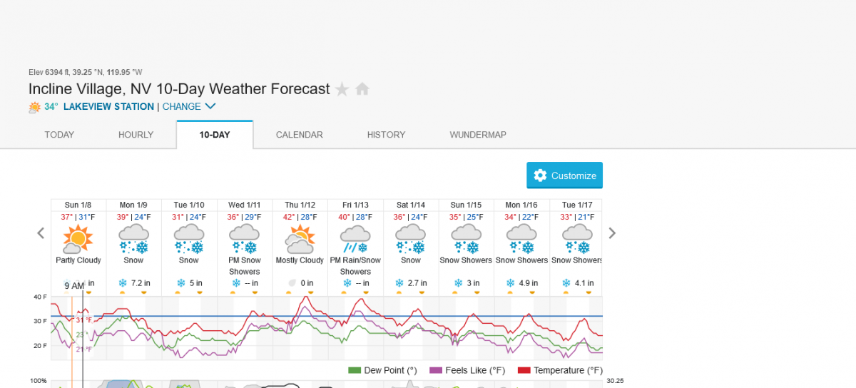
Top of Page Bottom of Page PermalinkFull Name: Druba
That's the discussion for the
That's the discussion for the weather district the Reno office is responsible for, not the town itself (FWIW)
Top of Page Bottom of Page PermalinkFull Name: Andy
Reno national weather service
Reno national weather service shows Palisades got 103 inches. How incorrect. Yet only 80 inches at Alpine. What bull since Alpine always, always gets more snow then palisades
Look at this site, Much more accurate nationwide: https://www.wunderground.com/forecast/us/nv/incline-village/KNVINCLI15
Top of Page Bottom of Page PermalinkFull Name: Andy
Corrected 30 feet much
Corrected 30 feet much earlier but forgot after preview to post. Judith, is there a way to change to preview and post (I do this soooooooooo often).
Top of Page Bottom of Page PermalinkFull Name: Andy
Tomorrow: Periods of snow.
Tomorrow: Periods of snow. Snow will be heavy at times especially during the morning. Morning high of 38F with temps falling to near 30.
Top of Page Bottom of Page PermalinkFull Name: Andy
Latest Update: Rain and
Latest Update: Rain and almost no snow. Knew it. Hyped wat to big
Top of Page Bottom of Page PermalinkFull Name: doctor
Jeremy Renner
Jeremy Renner
Top of Page Bottom of Page PermalinkFull Name: treat island
>>> Judith, is there a way
>>> Judith, is there a way to change to preview and post <<<
Andy, I don't understand what that means. Could you explain it, please?
Top of Page Bottom of Page PermalinkFull Name: Mice elf
peep the snotel plots. this
peep the snotel plots. this is the most accurate form of point data
https://wcc.sc.egov.usda.gov/nwcc/site?sitenum=518
nothing like a big dump in tahoe after a rain/freeze cycle to keep the snowpack interesting
Top of Page Bottom of Page PermalinkFull Name: Andy
My older brain cannot
My older brain cannot remember after hitting preview to then post message. Can we add a button or change existing "preview and post?' What happens is when I go to view,OOPS forgot to post. Over and over....Thx Judith
Top of Page Bottom of Page PermalinkFull Name: Andy
My older brain cannot
My older brain cannot remember after hitting preview to then post message. Can we add a button or change existing "preview and post?' What happens is when I go to view,OOPS forgot to post. Over and over....Thx Judith
PS: did it agin
Top of Page Bottom of Page PermalinkFull Name: DZ
.TAHOMA
TAHOMA
Top of Page Bottom of Page PermalinkFull Name: TommyGutt
brain cannot remember after
"brain cannot remember after hitting preview to then post message. Can we add a button or change existing "preview and post?' What happens is when I go to view,OOPS forgot to post. Over and over....Thx Judith "
This has Happened to me Several times as well we're almost retired! Have fun in da Snow Andy , lil niece is there quelque parts for the season
Top of Page Bottom of Page PermalinkFull Name: treat island
Could someone post a
Could someone post a screenshot of what you see when you're posting? I think I may not see the same screen (buttons) you do when posting.
Top of Page Bottom of Page PermalinkFull Name: Andy
It's the only box under add a
It's the only box under add a message 'preview'
Top of Page Bottom of Page PermalinkFull Name: Andy
Well-well. Whether folks
Well-well. Whether folks called for 1 inch max today. Now, almost 3 feet. Darn snow plow left a 4ft berm in front of driveway, ouch.
Top of Page Bottom of Page PermalinkFull Name: treat island
>>> It's the only box under
>>> It's the only box under Add a Message. It says 'preview',
but after you click on preview and see the preview, does it have a 'Post Message' button? Is it that you forget to click on that?
I guess I don't understand what's creating an obstacle or problem for you. And I'm older than you, Tommy, so I don't think that's it.
Top of Page Bottom of Page PermalinkFull Name: treat island
The Apple weather app said we
The Apple weather app said we'd have flurries for an hour this morning. Hah, just light rain.
And to all of the people who write judit with an 'h', you can keep your 'h', I don't have one and don't really want one. Someone once gave me a bunch of 'H' stickers so I could have an 'h'; I still have them in a folder somewhere.
Top of Page Bottom of Page PermalinkFull Name: GDTRFB
Top of Page Bottom of Page PermalinkFull Name: Andy
This is the 1st button. Is
This is the 1st button. Is there a way to make this Preview and Post since its the 2nd button I forget so often
Top of Page Bottom of Page PermalinkFull Name: Andy
And it keeps on coming.
And it keeps on coming. Light fluffy finally
Top of Page Bottom of Page PermalinkFull Name: treat island
Andy, I get it now. I didn't
Andy, I get it now. I didn't know it was an issue til you brought it up.
Serious question, do you use the preview function to see how what you wrote looks before posting? If it were the same button as 'Post Message', how would it work? If I understand the process you have in mind I can ask lava and HeyDavey about it. I prefer having 2 buttons; I have a rhythm of/to posting that makes 'Post Message' the action that follows typing and previewing.
Top of Page Bottom of Page PermalinkFull Name: intentionally blank
> Someone once gave me a
> Someone once gave me a bunch of 'H' stickers
Are you sure they weren't eyes?
Top of Page Bottom of Page PermalinkFull Name: treat island
Eyes?
Eyes?
Top of Page Bottom of Page PermalinkFull Name: treat island
Oh, you're thinking of them
Oh, you're thinking of them being what I would call on their sides
Top of Page Bottom of Page PermalinkFull Name: intentionally blank
Yeah, I didn't want to write
Yeah, I didn't want to write Is.
Top of Page Bottom of Page PermalinkFull Name: MarkD
I's works.
I's works.
Top of Page Bottom of Page PermalinkFull Name: DZ
I met a guy named H. When he
I met a guy named H. When he was born his parents put H____ on his birth certificate thinking they would fill in the blank later. They never did
Top of Page Bottom of Page PermalinkFull Name: GoneGoodbye
My kid is working and in
My kid is working and in employee housing at Kirkwood Mountain, elevation 7800 to 9800 feet. The past 2 days forecast was for 55'' !!!! He doesn't have to go anywhere, works hardest on the busy weekends, then skis during the slower week days. He loves it.
Top of Page Bottom of Page PermalinkFull Name: Mice elf
^ We used to call that
^ We used to call that building the "animal house".
(I'm sure it still is)
He's working/skiing some of the best inbounds terrain in north america
Top of Page Bottom of Page PermalinkFull Name: El Nino
I have a friend living in
I have a friend living in Mammoth right now and he says the whole town is shut down. The last dump was 4 feet on top of tons of snow they already have with more on the way. You can walk up to their second story deck now.
Top of Page Bottom of Page PermalinkFull Name: Andy
Wow youth!!! It takes me a
Wow youthfulness It takes me a week to cooperate from one outing. But I snow blowed 4-days straight. Soooooo tired, can't lift my arms. Was going to Alpine Meadows tomorrow, now next week. Getting older is not for the wak at heart.
Top of Page Bottom of Page PermalinkFull Name: Andy
Judith yes that will work: 2
Judith yes that will work: 2 buttons next to each other. PS" If long winded, preview. If short, post. TY
Top of Page Bottom of Page PermalinkFull Name: El Nino
The next 9 days could see "
The next 9 days could see " Massive Sierra Snowfall" on top of what is already on the ground
https://twitter.com/Weather_West/status/1613033145053646848
Top of Page Bottom of Page PermalinkFull Name: Mice elf
Keep the H!!!
Keep the H!!!
Top of Page Bottom of Page PermalinkFull Name: GDTRFB
Top of Page Bottom of Page PermalinkFull Name: GoneGoodbye
Bss, yes it still is Animal
Bss, yes it still is Animal House!
They have no restrictions on who can come and stay with the workers, leading to nightly parties into the morning hours.
I have to commend my kid, he lasted there a week there while ill, then asked to be transferred to Heavenly, where he had worked and lived on site before. Heavenly had a bit better control over the guest list and such. Ends up Kirkwood wanted to keep him so they placed him in housing with "older deadheads" and he is staying with that arrangement! He is my kid!!!!!!
We Are Everywhere!
Top of Page Bottom of Page PermalinkFull Name: GoneGoodbye
Bss, Hey at Kirkwood
Bss, Hey at Kirkwood Animal House do you remember which tower you were in?
Top of Page Bottom of Page PermalinkFull Name: Mice elf
Haha no way I never lived
Haha no way I never lived there, but friends did in high school and many years (some for way too long) after. I first partied at animal house in 10th grade! used to stay there sometimes during the real big storm cycles when the chairs still ran but the highways are all closed. I had a kw pass for around 15 years. About half of those were 100+ day seasons
Top of Page Bottom of Page PermalinkFull Name: Mice elf
San Diego sure getting some
San Diego sure getting some
wow. looking like north shore
https://m.youtube.com/watch?v=l9MQ8ZpmrOE
Top of Page Bottom of Page PermalinkFull Name: (~)};)StealYourFace
Shaping up to be an epic
Shaping up to be an epic spring.
hopefully off the DL by then.
I had a super cheap mid week pass ($199?) at Kirkwood back in the day. And you could camp in the lot. Tough place to get to after a big dump.