Death Valley Daze
Forums:
Sitting in a cheap motel up in the mountains in Burney CA getting back to civilization after camping out eight nights in Death Valley and the base of the eastern Sierra. Its a two nights drive back to PDX and was hoping to be in the office by Tuesday, but might be stuck instead in here until the snow storm passes. There is WIFI!
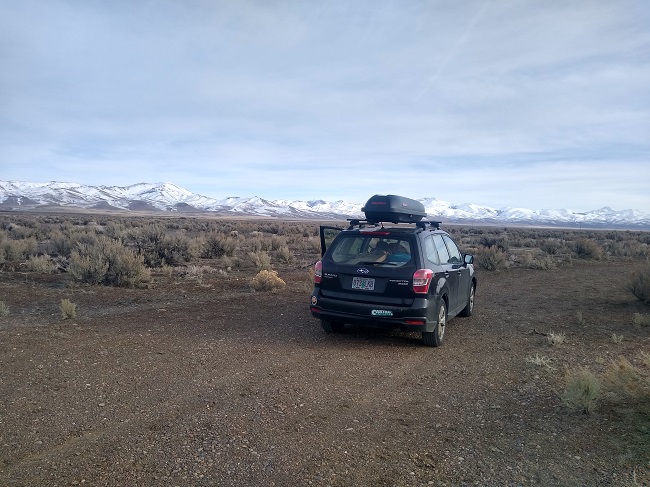
Went down there driving through eastern Oregon and then trough central Nevada on 305 and 376 through some amazing country. Somewhere on the Oregon-Nevada line:
Couldn't stop much to check it out because I was on a beeline to meet up with my brother (a fully vaccinated doctor) at Furnace Creek in Death Valley last Saturday at a campground spot he had obtained. Made it to the campground and stayed there two nights. Lots of amenities like water, flush toilets, and a little bit of cell service (enough to make spotty calls and tiny bit of internet), but crowded and noisy with lots of college kids and old RV dudes partying. At least the campsites were generous in size and not on top of each other. Close to lots of the popular sites like Zabriskie Point, Badwater, and the Star Wars locations:
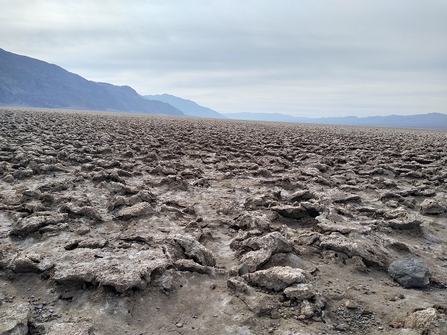
Devil's Golf Course:
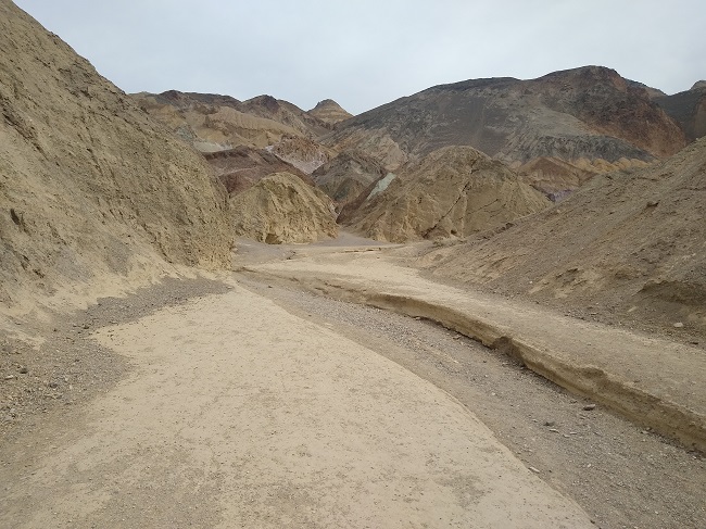
The entrance to the canyon where R2D2 was captured by the Jawas:
Headed north after that and will post more later.
- Log in to post comments
Top of Page Bottom of Page PermalinkFull Name: Ken D.
We then headed to the north
We then headed to the north end of Death Valley to the Mesquite Springs campground for three nights. Much more chill and scenic than Furnace Creek and still had water (hence the "springs"), but zero cell service:
It was also a good base camp for exploring the canyons in search of ghost towns and old mines:
Top of Page Bottom of Page PermalinkFull Name: Lance just me Newberry
As one who is sedentary by
As one who is sedentary by nature, I always enjoy these travel-log threads.
Please carry on.
Top of Page Bottom of Page PermalinkFull Name: Druba
Excellent pics Ken, thanks
Excellent pics Ken, thanks for sharing!
Top of Page Bottom of Page PermalinkFull Name: Zzzzzz
Awesome. Jealous of the
Awesome. Jealous of the trip.
Looks like a lot of fun.
Top of Page Bottom of Page PermalinkFull Name: fishcane
Utinni!
Utinni!
^^^^^The entrance to the canyon where R2D2 was captured by the Jawas:
Top of Page Bottom of Page PermalinkFull Name: doctor
Luv travel vlogs. Keep the
Luv travel vlogs. Keep the pics coming. Still hesitant to pull the trigger and take off somewhere. Will probably wait till I get the shot. Really waiting for Asia to open. Nepal is open. Haven't been there in 30 years. Thinking of heading there after the vaccine.
Top of Page Bottom of Page PermalinkFull Name: An organ grinder’s tune
i need a camp trip, looks rad
i need a camp trip, looks rad
Top of Page Bottom of Page PermalinkFull Name: Ken D.
Also checked out some
Also checked out some gigantic volcanic craters:
But Wednesday, a big storm blew in down from the Sierras. No precipitation in the valley, but the wind and blowing dirt and grit was ridiculous:
Still managed to hike up a nearby canyon, which provided some relief to the relentless wind.
Top of Page Bottom of Page PermalinkFull Name: Mtndog
Great photos
Great photos
Top of Page Bottom of Page PermalinkFull Name: jazfish
Dig it.
Dig it.
Top of Page Bottom of Page PermalinkFull Name: intentionally blank
Nice pics, Ken.
Nice pics, Ken.
I drove through northwestern Nevada on my way to Boise a couple of years ago, and really pleasantly surprised by the varied landforms and how much ground water there is up that way. Normallly, when I think of Nevada, I envision sun-scorched, God-forsaken desert vistas, much like Death Valley, but that NW corner of NV is pretty sweet.
Top of Page Bottom of Page PermalinkFull Name: MarkD
Cool trip and pics Ken.
Cool trip and pics Ken. Pretty f'n cold wasn't it?
Zang, you are envious.
Top of Page Bottom of Page PermalinkFull Name: 19.5 Degrees
Cool shots!
Cool shots!
Did your brother's batteries keep a charge (assuming there's solar on his van) with the foul weather / overcast?
Top of Page Bottom of Page PermalinkFull Name: Ken D.
>>>>Did your brother's
>>>>Did your brother's batteries keep a charge (assuming there's solar on his van) with the foul weather / overcast?
Yes, the only time the van has ran out of juice was during a trip to Oregon in August. We camped under trees for a few days and it was hot as blazes. Between the shade and the fridge working overtime to stay cool, it ran out of power. I brought my little portable charging station on this trip and it worked great except the portable solar panels kept getting knocked over in the wind and showered with dust so kept them put away most of the time.
Death Valley denizen:
After camping five nights in Death Valley, we drove over to the base of the Sierras. On our way over, we stopped in a quasi-ghost town of Darwin. The mine was shuttered long time ago and almost everyone moved out, but about 50 people (a lot of them on disability) have since taken up residency there. Apparently, there was a 2011 documentary about the town and its new residents which I will now have to see:
Purple cactus in Darwin:
Top of Page Bottom of Page PermalinkFull Name: Johnny D
Fantastic!
Fantastic!
There was just two other people at the Furnace Creek campground when Kai and I were there (of course the next day was the hottest on record!).
Thanks for sharing
Top of Page Bottom of Page PermalinkFull Name: Ken D.
We spent the next three
We spent the next three nights camped in a nearly deserted campground in Owens Valley just south of Lone Pine in between the Sierras and Inyo mountains:
The storm continued and in addition to the winds, we were now getting sleet, snow, and freezing temperatures at night. We were still able to get out and about and check out the nearby sights, including the site of the Manzanar interment camp where 11,000 civilians of Japanese ancestry were incarcerated during WW2:
Top of Page Bottom of Page PermalinkFull Name: Ken D.
Dang Johnny. I couldn't
Dang Johnny. I couldn't imagine going to Death Valley in the summer. Did you do all your exploring at night or at the break of dawn?
We also checked out an area called the Alabama Hills at the base of the highest Sierra - Mt. Whitney. The Alabama Hills are a sprawling collection of rock piles and canyons and the filming location for countless Westerns and other movies.
We tried driving up the Whitney portal, but the road was stiill closed for the season.. Funny how the highest point in the lower 48 is about 100 miles from the lowest point in the western hemisphere:
We spent the last day roaming around the base of the Intyo Mountains looking for petroglyphs and old dolomite mines. Didn't find the rock art, but found the old mines:
Base of Inyos looking over what is left of Owens Lake after LA sucked up all the water coming down from the Sierras:
Top of Page Bottom of Page PermalinkFull Name: Ken D.
Took US 395 most of the way
Took US 395 most of the way back and stopped by June Lake:
When I got to Susanville, my Waze app took me way out into the boonies on Forest Service roads out in rural Shasta and Siskiyou counties. Was lucky to finally get a motel in Burney. The area got hammered last night and woke up to eight inches of snow. Traveling from Burney over to Shasta and up over Siskiyou Pass was nerve-wracking. I-5 around Shasta was the worst with the road covered in ice and snow with no discernible lanes. Had to pull over for a while until the snow plows came. Fortunately, there was little snow going over Siskiyou Pass but high winds still made for some white knuckled driving:
Top of Page Bottom of Page PermalinkFull Name: doctor
My dad still has 10 acres of
My dad still has 10 acres of desert land by Independence he bought in the 60's or 70's. He still gets inquiries by people to buy it. Apparently there's lot's of oil there. He won't sell it for some reason. Pay's taxes on it every year and hasn't been there since the 70's. I was by there in July.
Top of Page Bottom of Page PermalinkFull Name: Zzzzzz
>>>Zang, you are envious.
>>>Zang, you are envious.
That too.
That purple cactus is rad. It's time for a desert trip.
Top of Page Bottom of Page PermalinkFull Name: An organ grinder’s tune
are you tent camping?
are you tent camping? looks a little on the chilly side.
Top of Page Bottom of Page PermalinkFull Name: Ken D.
>>>are you tent camping?
>>>are you tent camping?
Yes, I was in a tent. My brother has his van, but it can be a bit cramped (slept in the van during an Alaskan trip because of the bears and mosquitoes). It got down to freezing several nights, but I have a good sleeping bag, a Pendleton blanket, and a Mexican blanket so I stay warm enough. The wind and constant flapping of the tent was the worst part.
Top of Page Bottom of Page PermalinkFull Name: Mice elf
Good stuff. Man I miss the
Good stuff. Man I miss the east side.
Top of Page Bottom of Page PermalinkFull Name: El Nino
>>>>Funny how the highest
>>>>Funny how the highest point in the lower 48 is about 100 miles from the lowest point in the western hemisphere:
There was a great article in Rolling Stone many years ago about a couple of guys who did that hike in the summer. They had water drops along the route, but still almost died. Apparently when hiking across the valley you can break through the crust. Under the crust is hot mud that immediately sets up on your boots. They planed to sleep in the day in a specially designed tent and hike at night. They tested the tent at the a campground in Death Valley and it worked to keep it cooler, but out in the actual valley it ended up hotter than outside because the campground had grass and the valley floor radiated heat into the tent.
Top of Page Bottom of Page PermalinkFull Name: intentionally blank
Hike? There's a 135 mile
Hike? There's a 135 mile footrace from Death Valley to Whitney Portal every summer.
Top of Page Bottom of Page PermalinkFull Name: Alan R
Nice trip. Surprised you didn
Nice trip. Surprised you didn't stop at the hot springs outside Bridgeport if you passed by on 395.
Top of Page Bottom of Page PermalinkFull Name: Ken D.
>>>>Surprised you didn't stop
>>>>Surprised you didn't stop at the hot springs outside Bridgeport if you passed by on 395.
Hot springs were tempting but I have not been vaccinated yet and wasn't enamored with the idea sharing a pool with strangers. I should become eligible next month and it will be a much different story after that.
Top of Page Bottom of Page PermalinkFull Name: _________
Loving This Ken !! Thanks
Loving This Ken !! Thanks much
Top of Page Bottom of Page PermalinkFull Name: New & Improved
Nice pics, Ken.
Nice pics, Ken.
I need post some pics from our first camping trip of 2021 through the Superstition Mtns east of Phoenix.
We have our first trip to Utah starting in a couple weeks on the 27th. Probably out near Keg Knoll etc south of Green River. Weather is shaping up nicely. :)
Top of Page Bottom of Page PermalinkFull Name: Ken D.
>>>> Superstition Mtns east
>>>> Superstition Mtns east of Phoenix.
That's a nice area, especially in winter. Did you find the Lost Dutchman's mine?
Top of Page Bottom of Page PermalinkFull Name: New & Improved
We did a good portion of the
We did a good portion of the Lost Dutchman Trail, Black Mesa, Weaver's Needle, etc.
No treasure, but the springs were wet and bountiful!
Top of Page Bottom of Page PermalinkFull Name: jazfish
When I lived in Mesa I had a
When I lived in Mesa I had a girlfriend that lived in Apache Junction. Those Superstitious Mts are cool as hell to explore.
Top of Page Bottom of Page PermalinkFull Name: jazfish
I remember a bar called
I remember a bar called Tortilla Flats, I think.
Top of Page Bottom of Page PermalinkFull Name: New & Improved
Springzzzzzzz.....
Springzzzzzzz.....
Top of Page Bottom of Page PermalinkFull Name: New & Improved
dos mas...
dos mas...
Top of Page Bottom of Page PermalinkFull Name: Lance just me Newberry
>>> because of the bears and
>>> because of the bears and mosquitoes<<<
Hence sedentary.