Another winter storm

Full Name:
Thredkilla
Forums:
Everyone has their own weather extremes to contend with and after a decent weather week, we are going to get nailed again by a winter storm on Friday here in northeastern Ohio. I can usually handle the snow, but a 1/4 inch of ice is another story. I live in what is called the "Snow Belt" & I bought snow tires this year for the first time ever. I hope I am able to drive into work Saturday.
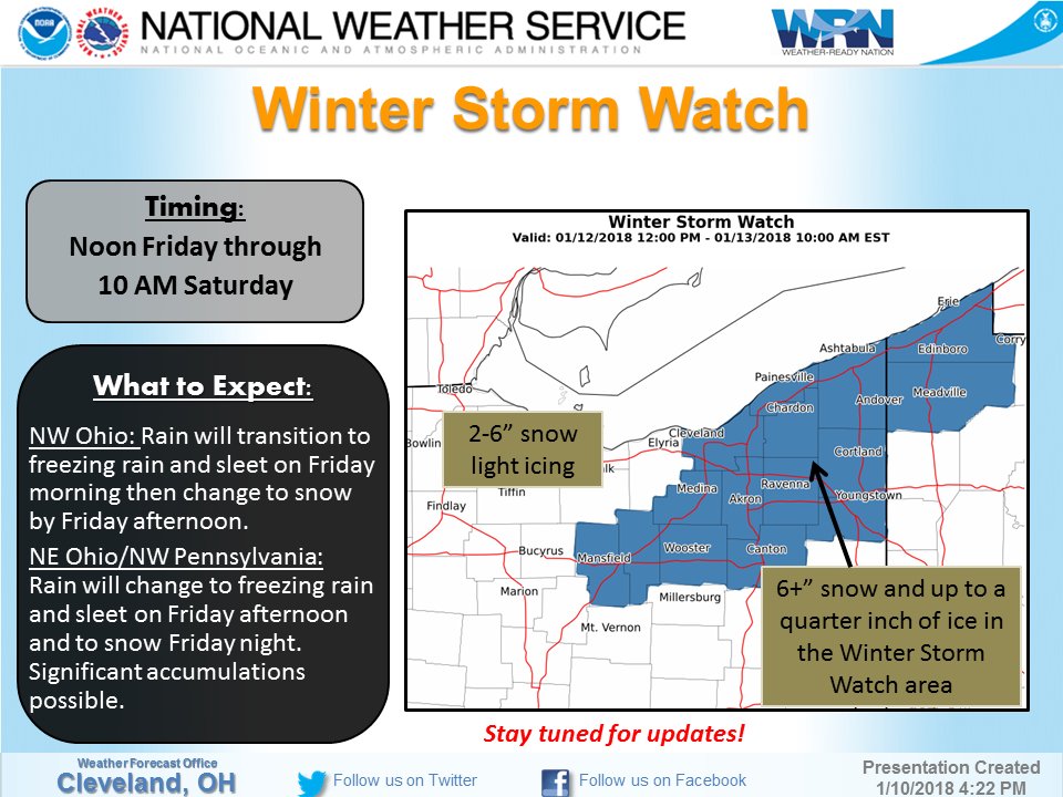
Watches are for 48 hours or more out, Warnings are for 24 hours or less. Here is our latest storm watch!
http://www.cleveland.com/weather/blog/index.ssf/2018/01/national_weather...
https://forecast.weather.gov/wwamap/wwatxtget.php?cwa=cle&wwa=winter%20s...
>>> Colder air will spread across the area on Friday. Rain is expected to change to freezing rain, then to sleet and then snow Friday into Friday evening as low pressure develops. The strength and track of the low pressure center remains uncertain but there is the potential for a significant glaze of ice followed by accumulating snow Late Friday and Friday night.
WINTER STORM WATCH IN EFFECT FROM FRIDAY AFTERNOON THROUGH SATURDAY MORNING...
* WHAT...Heavy mixed precipitation possible. Total snow accumulations of 6 to 10 inches, with localized amounts up to 12 inches are possible. Ice accumulations of one tenth to around a quarter of an inch are possible.
* WHERE...Portions of northwest Pennsylvania and north central and northeast Ohio.
* WHEN...From Friday afternoon through Saturday morning.
* ADDITIONAL DETAILS...Ice accumulations could lead to power outages and tree damage. Travel could become dangerous, including the evening commute on Friday. Blowing snow is possible Friday night as winds increase. Temperatures will drop below freezing from west to east during the day on Friday and be in the teens by early Saturday morning.
- Log in to post comments
Top of Page Bottom of Page PermalinkFull Name: Sideshow Bob
Forecast for 1.5 days of
Forecast for 1.5 days of steady rain and temp's in the '50's around here for Fri/Sat, given the 1.5' of snow on the ground, gonna be some Biblical flooding in store . . .
Top of Page Bottom of Page PermalinkFull Name: Thredkilla
Batten down the hatches Bob!
Batten down the hatches Bob! For real though, here's to you experiencing NO flooding!
Top of Page Bottom of Page PermalinkFull Name: Sideshow Bob
Back in the late 1970's when
Back in the late 1970's when I attended Univ of Pittsburgh & my parents lived in the Pocono's, I used to travel I-80 between home & school, I traveled thru the town of DuBois PA, which was on the western face of the Appalachians/Allegheney's, this was my Introduction to Lake Effect Snow, those poor folks that settled that area sure drew the Short Straw, as it seemed to Snow there pretty much every day from Oct to May. When I subsequently met Deadheads thru tape trading circles who went to Syracuse U, after many road trips up that way, I always wondered, did the folks who settled the Syracuse NY area have done something seriously Wrong where they originally came from to have been sent to settle that area? Or were they just plain Cursed?
Top of Page Bottom of Page PermalinkFull Name: Thredkilla
>>> as it seemed to Snow
>>> as it seemed to Snow there pretty much every day from Oct to May. <<< This is how I first experienced Lake Effect too! I used to work in Chagrin Falls, OH and I swear it used to snow there 3" - 6" everyday. Not so much in the last few years, but this year is making up for past year's low snow totals. The north coast towns have been getting hit pretty hard this year with snow. It usually blows over them and dumps more inland. Lake Erie is supposedly 70% frozen over already which will supposedly cut down on the lake effect.
Top of Page Bottom of Page PermalinkFull Name: skyjunk
Tbe good old snow belt, lived
Top of Page Bottom of Page PermalinkFull Name: Sideshow Bob
Hope you don't have any power
Hope you don't have any power outages Mr Fark, I'm sitting pretty on top of a hill @ elevation 710' so no flood worries for me. Big drama of the day today was getting my oil delivery guy down (& back out) my still icy driveway, I'm good 'till late Feb now . . .